|


The Courtyard
147 Worcester Road
Hagley
West Midlands
DY9 0NW
Tel: 01562 882976
Fax: 01562 882164
DX: 15441 Hagley
Email:
[email protected]


|
Off-the-shelf
solutions to extend gINT to its full potential.
LA
gINT Tools are built for use with the gINT AGS3 data structure but
can be adopted to suit any data structure. They are specifically
aimed at the UK market, but many are applicable worldwide. These
Tools are in addition to the standard files shipped with all gINT
Software products and the free downloads available from gINT Software. Download
brochure
(1844 KB)
Contaminated
Land Tool
Data
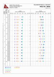
management, statistical analysis to CLR7, visualisation and reporting
of soil contamination data.
The tool enables import
of contaminant data from AGS format files (or direct input of
data), carries out statistical analysis of data as defined in
CLR7 based on user defined zonation of the site (populations defined
by geology type, sample depth and location sub-division), user-defined
confidence limits and user-defined exclusion of outliers. The
tool identifies SGV exceedence and plots results graphically
in plans, cross-sections, tables and histograms that highlight
fails and outliers. Example
Output (1675 KB)
|
|
Import
AGS, XLS, CSV, TXT, and MDB Data. |
|
Import
DXF base plan. |
|
Database
designed around the AGS3 data structure. |
|
Entry
or import of logging information and geologic interpretation.
|
|
Statistical
populations based on determinand, test type, units, and site
sub division. |
|
Statistical
populations based on sample depth, or depth range such as geology
code. |
|
User
defined land use for each site sub division or one land use
for the entire site/project. |
|
User
defined determinands, SGV, test type, unit and land use combinations. |
|
User
defined minimum population size to calculate statistics. |
|
Exclusion
of statistical outliers from statistical populations. |
|
User
defined upper percentile bound for mean value test. |
|
User
defined critical percent values for maximum value test. |
|
Screening
of results and computation of the statistical tests defined
in CLR7. |
|
No
practical limit to the number of samples or test results. |
|
Output
of colourful and monochrome report quality plans, fences (sections),
tables, and histograms that highlight the fails and outliers
filtered for user definable determinands, site sub divisions,
and determinand groups (i.e. Organics, PAHs
). |
|
Export
reports as PDF, BMP, JPG, DXF, GDW
|
|
Filter
reports for outliers, sample depth, and depth range such as
geology code. |
|
Use
of your existing logs and other gINT reports with the tool.
|
|
Export
data using Queries to Excel for further analysis. |
|
Export
of contouring data. |
|
Connect
to GIS Software. |
|
Free
technical support covering installation, licensing issues and
any other support needed to keep your Tool running. |
|
Comprehensive
PDF manual. |
Free
online demonstration and 30 day trial available!!
Basic
Tools
| LA
gINT Tool |
Description |
Price
Ex
VAT |
| AGS
3.1 Legend Symbols |
Over
140 BSI material symbols for common soils (based on 1 major
constituent and up to 3 minor constituents) and rocks using
the AGS 3.1 numeric naming system.
|
£
50.00 |
| Descriptive
Legend Symbols |
Over
140 BSI material symbols for common soils (based on 1 major
constituent and up to 3 minor constituents) and rocks using
the gINT descriptive naming system.
|
£
50.00 |
| Legend
Symbols Auto Picker
|
gINT
Rules which automatically pick the legend code based on a
strata description. |
£
50.00 |
| Legend
Symbols Auto Converter |
gINT
Rules Add-ins which automatically converts descriptive legend
codes (gINT standard) to numeric legend codes (AGS 3.1 standard)
and vice versa.
|
£
50.00 |
| Coordinate
Calculator |
gINT
Rules add-ins to calculate NAT coordinates and elevation based
on LOC coordinates and elevation.
|
£
50.00 |
| Railway
Symbols |
39
material symbols based on RT/CE/C/039 - issue 2 - December
2003 for railways geotechnical sections, associated tile symbols,
legend key graphical text report and A4 portrait figure sheet
drawing block.
|
£
50.00 |
| Drawing
Templates |
Contains
9 drawing borders formatted to A4, A3 and A1 size, including
2 title block styles, track codes and figure title block user
report variable text links.
|
£
35.00 |
Training
and Support Options
- Free
support covering installation, licensing issues and code maintenance.
- 30
min WebEx training and 30 days full technical support £50.
- Additional
technical support at £35/hour.
- Yearly
Support Agreement £120.
Customisation
Available
For
example:
- Custom
tools to streamline importing of data.
- Additional
statistical test for Contaminated Land Tool.
Licensing
Contaminated
Land Tool: Licensed on a per seat basis, and may only be used on
computers based in an office that holds a primary license of gINT
Professional and a license of this Tool. This Tool may be installed
on multiple computers within a licensed office, but may only be
run concurrently by PC's numbering up to the number of Tool licenses
held.
Other
Tools: Licensed on a per office basis.
System
Requirements
- Requires
gINT version 6.1.032 or later.
- Minimum
hardware as specified by gINT
- Software.
Note:
It is the responsibility of the user to check and validate all gINT
Tools provided by Leeke Associates to ensure they are appropriate
for the particular application.
|
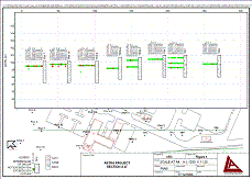
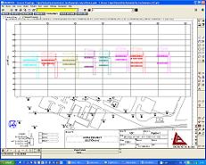
Contamination Sections |
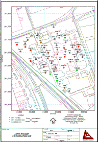
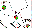
Contamination Map
|
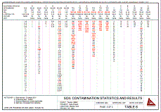
Contamination Table
|
| 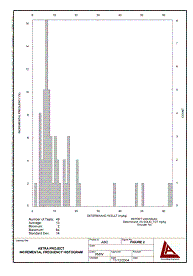
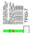
Contamination Histogram
|
| 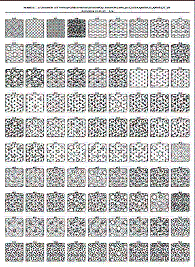
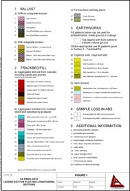
Legend
Symbols
|
Borders
|
Instrumentation
Reports
|
| 
Sections
|
| 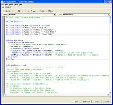
gINT Rules
|
Railway Symbols
|
| |
|